Click for more products.
No produts were found.
Click for more products.
No produts were found.
Welcome

3D relief map of Queyras Ubaye 3DMap

A HIGHLY ACCURATE 3DMAP RELIEF MAP

Discover the Queyras Ubaye region in a whole new way with this 3D Map. This hard-to-reach region is a hiker's paradise. The 3DMAP map offers unique precision, so you'll easily find the region's massifs and important paragliding take-off and landing points, as well as a host of other useful data.

Dimensions (cm): 41 x 61

Scale: 1/120,000

Possibility of adding a frame

Read moreShow less
€39.90 (tax incl.)
In stock, immediate delivery!
Close
Reference:
2998
Description

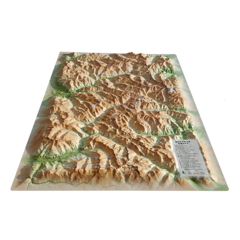
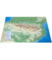
A complete relief map

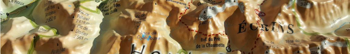
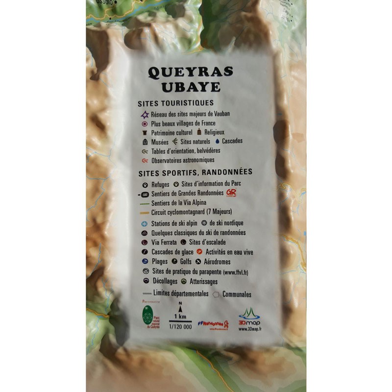
The relief map of the Queyras Ubaye region introduces you to one of the most beautiful areas of the Southern Alps. This comprehensive map will guide you in your outdoor activities. For example, you'll find the main paragliding sites in the area. The 3D MAP map also provides a wealth of other important information. These include natural sites, mountain huts, glaciers, airfields and much more.

The revolutionary 3D map

3DMap brand maps are made entirely in France. They have revolutionized the world of relief maps. They are the fruit of major R&D efforts, and their incomparable qualities mean that they are now among the best-selling relief maps in France.

What's more, 3D processing software has been specifically designed to make the most of geographic information, such as bathymetric data.

Tips from the Air et Aventure team:

For a better presentation, we suggest you complete your relief map with a frame(available in 4 colors) that you can easily hang on the wall, for example. It's also a good idea to add a CFD Kit to your order, enabling you to easily mark your different routes and itineraries with needles and thread, also available in several colors.

Don't forget thatAir et Aventure also offers many other 3D maps from 3DMap. Don't hesitate to discover them!


Zoom sur la carte en Relief du Massif des Ecrins

Read moreShow less
Product Details
2998

Data sheet

Type of map
Map
TYPE OF PRODUCTS
RELIEF MAP
BF Types
Relief maps
Customers who bought this product also bought:
€39.90 (tax incl.)
Map of France's most beautiful mountains This relief map features the Provence Alpes Côte d'Azur region. Thanks to the quality of its design, you'll be able to easily locate the region's mountains and the ideal places...
In stock, immediate delivery!
€39.90 (tax incl.)
Map of Physical France This relief map shows the physical France in relief. The quality of the printing makes it easy to spot the mountains of the different regions and the ideal places to take off or land a...
In stock, immediate delivery!
€39.90 (tax incl.)
Map of the Alpine Arc This relief map shows the Alpine Arc in relief. The quality of the printing makes it easy to identify the mountains of the different regions and the ideal places for paragliding take-offs and...
In stock, immediate delivery!
€39.90 (tax incl.)
A precise and practical relief map The Sainte Baume - Sainte Victoire relief map shows you this region from the air. Thanks to its 3D relief, you'll be able to easily locate the region's mountain ranges and...
In stock, immediate delivery!
€35.90 (tax incl.)
A frame to enhance your relief map This stylish wooden frame is ideal for 3DMap embossed maps. Color: White / Black / Wood / Ash Dimensions (cm): 43 x 63 Width (mm) : 15 Thickness (mm) : 30
In stock, immediate delivery!
Related products
€34.95 (tax incl.)
Posters of mythical paragliding spots Furnish your home with colorful, high-quality art posters.Dimensions (cm) : 50 x 70
In stock, immediate delivery!
€35.90 (tax incl.)
A frame to enhance your relief map This stylish wooden frame is ideal for 3DMap embossed maps. Color: White / Black / Wood / Ash Dimensions (cm): 43 x 63 Width (mm) : 15 Thickness (mm) : 30
In stock, immediate delivery!
€39.90 (tax incl.)
Relief map for recreational and educational use Fly over Savoie with this 3DMap relief map. Made 100% in France, it's perfectly accurate. You'll easily find what you're looking for, thanks to the wealth of...
In stock, immediate delivery!
€19.90 (tax incl.)
Relief map for recreational and educational use Discover this mini relief map of Tignes Val d'Isère. Focusing on the town of Tignes in Savoie, this uncommonly accurate map features the region's glaciers, peaks and...
On order
€19.90 (tax incl.)
Relief map for recreational and educational use Discover this mini relief map of the Mont Blanc tour. Centered on Europe's most famous peak, this uncommonly accurate map will give you a whole new perspective on the...
In stock, immediate delivery!
€39.90 (tax incl.)
Map of France's most beautiful mountains This relief map features the Hautes Alpes region. Thanks to the quality of its design, you'll be able to easily locate the region's mountains and the ideal places to take off...
In stock, immediate delivery!

Settings

Menu