Click for more products.
No produts were found.
Click for more products.
No produts were found.
Welcome

3DMap Drôme Ardèche Relief Map

Map of départements 07 and 26

This relief map shows the mountains of Ardèche and Drôme. The quality of the printing makes it easy to spot the region's mountains and the ideal places to take off or land a paraglider, as well as a host of other useful information.

Dimensions (cm) : 41 x 61

Scale : 1:400,000

Possibility of adding a frame

Read moreShow less
€39.90 (tax incl.)
In stock, immediate delivery!
Close
Reference:
4056
Description

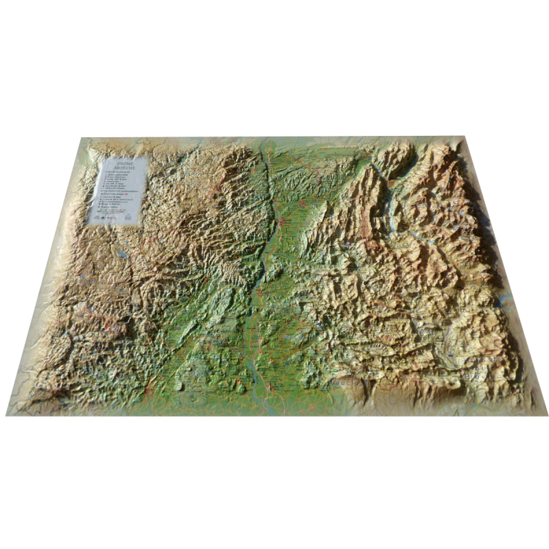
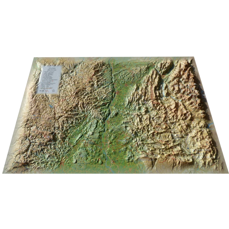
Discover the landforms on either side of the Rhône valley

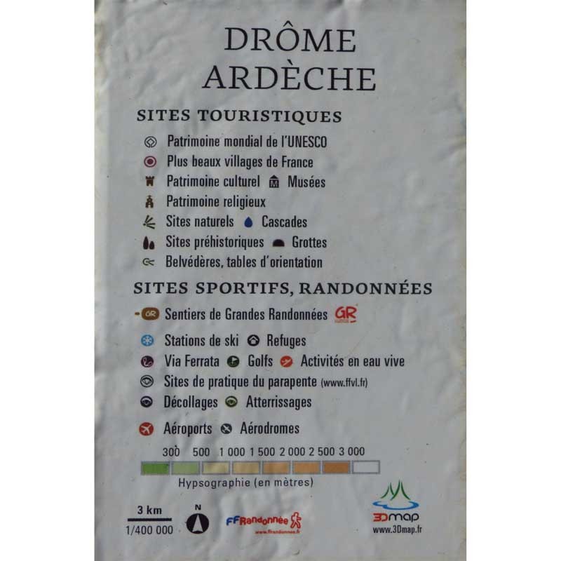
Decorate your living room with a relief map of Drôme Ardèche. From the Vercors to the Monts d'Ardèche regional park, discover the sumptuous mountains and valleys on either side of the Rhône. See also paragliding sites, ski resorts, Via Ferrata sites, and lots of other information such as :

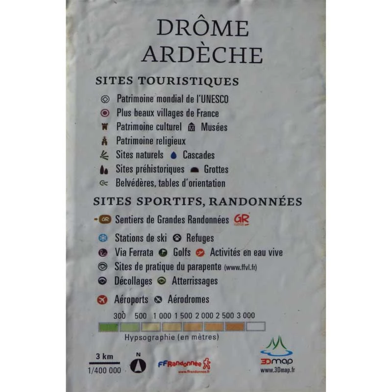
  • UNESCO World Heritage sites
  • France's most beautiful villages
  • Cultural heritage
  • Museums
  • Religious heritage
  • Natural sites
  • Waterfalls
  • Prehistoric sites
  • Caves
  • Belvederes, orientation tables
  • Long-distance hiking trails
  • Refuges
  • Alpine and Nordic ski resorts
  • Via Ferrata
  • Golf courses
  • White-water activities
  • Paragliding sites (www.ffvl.fr)
  • Take-offs, Landings
  • Airports, Aerodromes

100% FRENCH MANUFACTURING :

3DMap brand maps offer printing quality far superior to that of older relief maps. This is the fruit of major R&D efforts and French design.

In addition, 3D processing software has been specifically developed to enable wider use of geographic information, such as bathymetric data.

For a better presentation, complete your relief map with a suitableframe (available in 4 colors).

And don't forget thatAir et Aventure also offers many other 3D maps from 3DMap. Don't hesitate to discover them!

Read moreShow less
Product Details
4056

Data sheet

Type of map
Map
TYPE OF PRODUCTS
RELIEF MAP
BF Types
Relief maps
Related products
€35.90 (tax incl.)
A frame to enhance your relief map This stylish wooden frame is ideal for 3DMap embossed maps. Color: White / Black / Wood / Ash Dimensions (cm): 43 x 63 Width (mm) : 15 Thickness (mm) : 30
In stock, immediate delivery!
€24.00 (tax incl.)
Vol-rando in France: topo-guide to the most beautiful flights Discover the most beautiful vol-randos in France. From the Corsican coast to the magnificent mountain pastures of Haute-Savoie, via the dormant volcanoes...
In stock, immediate delivery!
€39.90 (tax incl.)
Relief map for recreational and educational use This relief map features the Isère department. Thanks to its perfect accuracy, you'll easily find the region's mountain ranges and the ideal places for paragliding...
In stock, immediate delivery!
€39.90 (tax incl.)
Map of France's most beautiful mountains This relief map features the Hautes Alpes region. Thanks to the quality of its design, you'll be able to easily locate the region's mountains and the ideal places to take off...
In stock, immediate delivery!

Settings

Menu