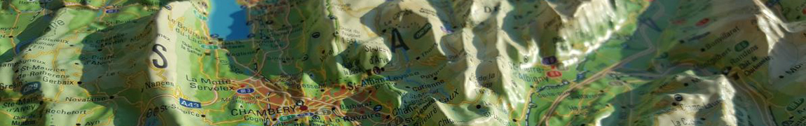
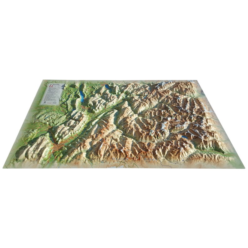
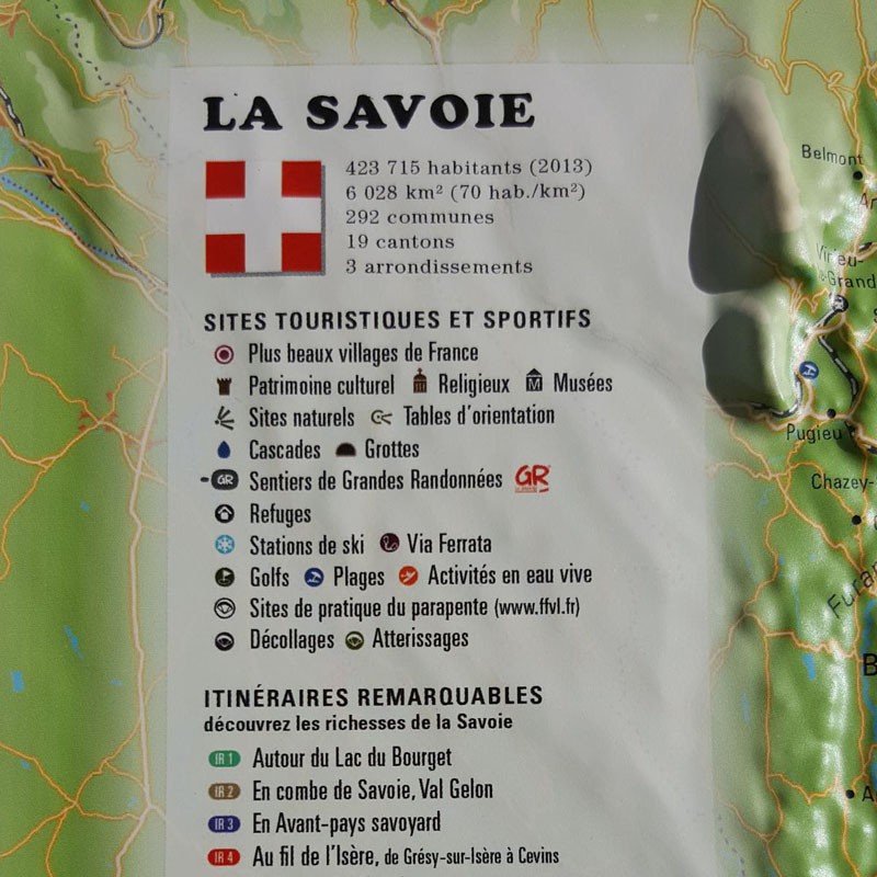
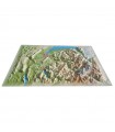
Click for more products.
No produts were found.
Click for more products.
No produts were found.
Welcome

3DMap Savoie Relief Map

Relief map for recreational and educational use

Fly over Savoie with this 3DMap relief map. Made 100% in France, it's perfectly accurate. You'll easily find what you're looking for, thanks to the wealth of information it contains: mountain ranges, natural sites, refuges and much more .

Dimensions (cm): 41 x 61

Scale: 1/175,000

Possibility of adding a frame

Read moreShow less
€39.90 (tax incl.)
In stock, immediate delivery!
Close
Reference:
2991
Description

SAVOIE IN RELIEF

This beautiful relief map lets you discover the Savoie region. From the Grenoble Y to Annecy, via Chambéry, you'll find all the paragliding sites and major mountain ranges in the region. This rare quality map will guide you through the Vercors, Chartreuse, Vanoise and many other Savoyard massifs. You'll find all the information you need, including observatories, spas and airfields:
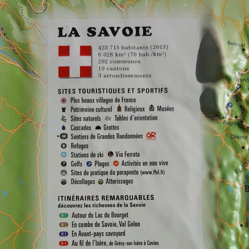
  • Natural sites
  • Glaciers and peaks
  • via Ferrata sites
  • Natural sites
  • France's most beautiful villages
  • Refuges
  • Ski resorts
  • Museums
  • Golf courses
  • Beaches
  • Monuments and castles of legend
  • Religious sites
  • Hiking trails
  • Trails
  • White water activities
  • Remarkable itineraries
  • The network of Vauban sites
  • Orienteering tables
  • Hydrological, natural and hypsometric data
  • Administrative data

EXCEPTIONAL QUALITY:

Made 100% in France, 3DMap brand maps are the fruit of major R&D efforts, offering unrivalled quality that sets them apart from traditional relief maps.

To enable wider use of geographic information, such as bathymetric data, 3D processing software has been specifically developed.

To enhance your presentation, you can mount your Savoie relief map on a frame (available in 4 colors).

Air et Aventure also offers a wide range of other 3D maps from 3DMap. Don't hesitate to discover them!
Zoom sur la carte en relief de la Savoie


Read moreShow less
Product Details
2991

Data sheet

Type of map
Map
TYPE OF PRODUCTS
RELIEF MAP
BF Types
Relief maps
Customers who bought this product also bought:
€39.90 (tax incl.)
Relief map for recreational and educational use Discover the Haute-Savoie department as you've never seen it before with this 3DMap relief map. It's uniquely accurate, so you'll easily find the region's mountain...
In stock, immediate delivery!
€35.90 (tax incl.)
A frame to enhance your relief map This stylish wooden frame is ideal for 3DMap embossed maps. Color: White / Black / Wood / Ash Dimensions (cm): 43 x 63 Width (mm) : 15 Thickness (mm) : 30
In stock, immediate delivery!
Related products
€35.90 (tax incl.)
A frame to enhance your relief map This stylish wooden frame is ideal for 3DMap embossed maps. Color: White / Black / Wood / Ash Dimensions (cm): 43 x 63 Width (mm) : 15 Thickness (mm) : 30
In stock, immediate delivery!
€24.00 (tax incl.)
Vol-rando in France: topo-guide to the most beautiful flights Discover the most beautiful vol-randos in France. From the Corsican coast to the magnificent mountain pastures of Haute-Savoie, via the dormant volcanoes...
In stock, immediate delivery!
€28.00 (tax incl.)
Cold doesn't have to get in the way of great adventures Wherever you go, the new Niviuk bonnet is ideal for protecting you from low temperatures.Technical Details Materials: 100% acrylicColors: Reversible : dark gray...
On order
€19.90 (tax incl.)
Relief map for recreational and educational use Discover this mini relief map of Lake Annecy. A famous lake in the French Hautes-Alpes region, Lake Annecy is world-famous. Its location and scenery make it a must for...
On order

Settings

Menu